THINK TANKS-RETHINK TOURISM
Stella Taousiani
2014 | School of Architecture, University of Cyprus
Diploma Thesis Project | Supervisors: Panayiota Pyla, Socrates Stratis, Nadia Charalambous
Στέλλα Ταουσιάνη
2014 | Τμήμα Αρχιτεκτονικής Πανεπιστημίου Κύπρου
Διπλωματική Εργασία | Επιβλέποντες : Παναγιώτα Πύλα, Σωκράτης Στρατής, Νάντια Χαραλάμπους
Η παρούσα διπλωματική κινείται παράλληλα γύρω από δύο βασικές θεματικές. Από τη μια γίνεται μελέτη για την αναβίωση μιας «μολυσμένης» βιομηχανικής περιοχής, -περιοχή πρώην Διυλιστηρίων στη Λάρνακα- ενώ ταυτόχρονα διερευνάται η έννοια του τουρισμού.
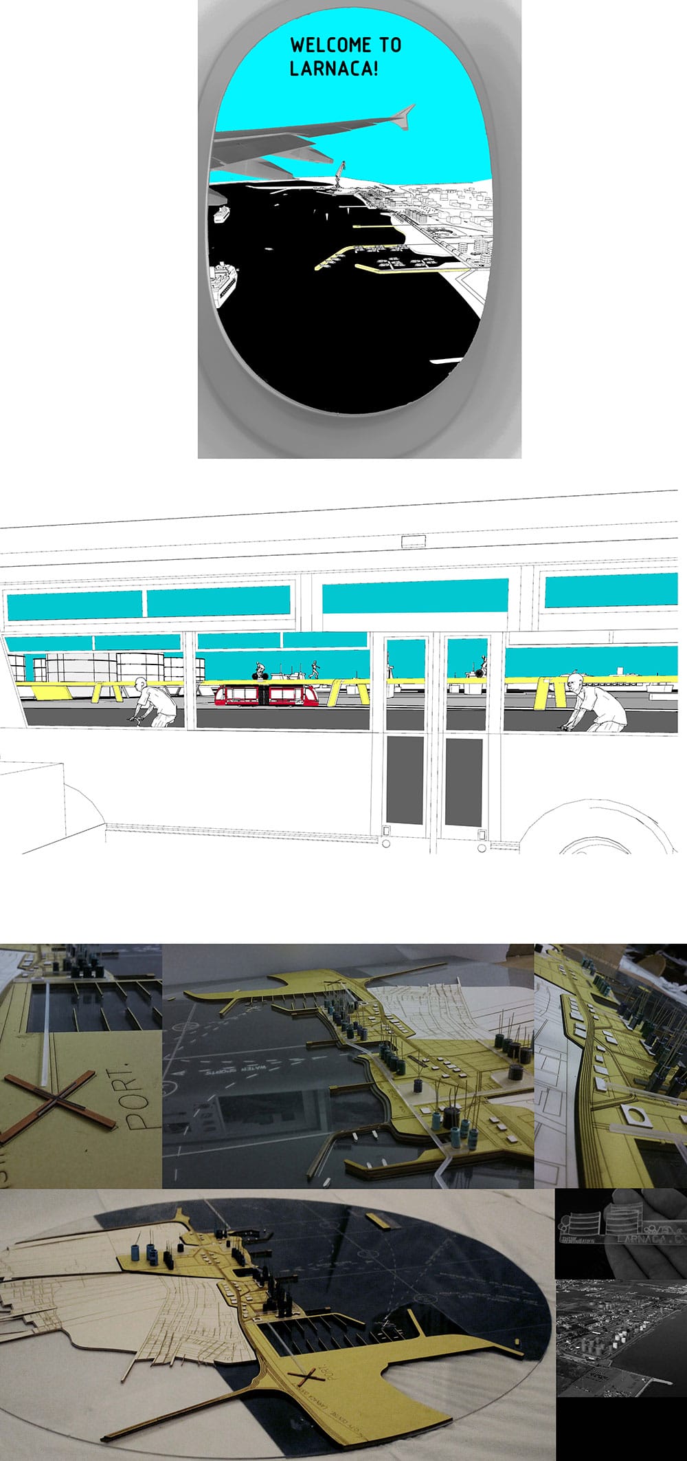
Λόγω της σημαντικής στρατηγικής της θέσης, η περιοχή μελέτης αποκτά άμεση συσχέτιση με τον τουρισμό και αποτελεί σημείο αφετηρίας για ανάλυση και της γενικότερης έννοιάς του. Ξεκινώντας από τη μικρότερη κλίμακα, αποτελεί την κοντινότερη περιοχή γειτνίασης με το μελλοντικό επιβατικό λιμάνι. Γι αυτό τον λόγο αποτελεί αντικείμενο συζήτησης από διάφορους φορείς, με προτάσεις που έχουν ως στόχο τη μετατροπή της σε μια περιοχή «τουριστικής ανάπτυξης». Προχωρώντας σε μεγαλύτερες κλίμακες αρχίζει να αποκτά δυνατότητα συσχετισμού τόσο με το αεροδρόμιο και την πόλη της Λάρνακας, όσο και σε γενικότερο πλαίσιο, με ολόκληρη την Κύπρο η οποία αυτοπροβάλλεται στο εξωτερικό ως ένας προορισμός «θάλασσα-ήλιος-άμμος» (sea, sun, sand).
Τι ακριβώς σημαίνουν όμως οι όροι «τουρίστας» και «τουριστική ανάπτυξη» ; Πώς μπορεί αυτή η ξεχασμένη, «άτοπη», αποκλεισμένη από την πόλη περιοχή, να γίνει ένα ζωντανό και βιώσιμο κομμάτι του ιστού της, καθ’όλη τη διάρκεια της ημέρας, όλες τις εποχές του χρόνου;
Με στόχο την απάντηση των πιο πάνω ερωτημάτων, γίνεται αρχικά μια μελέτη και επαναπροσδιορισμός της έννοιας του τουρισμού. Ο τουρίστας και ο κάτοικος αντιμετωπίζονται ως επισκέπτες που μοιράζονται και κατοικούν τον ίδιο χώρο για διαφορετικά χρονικά διαστήματα.
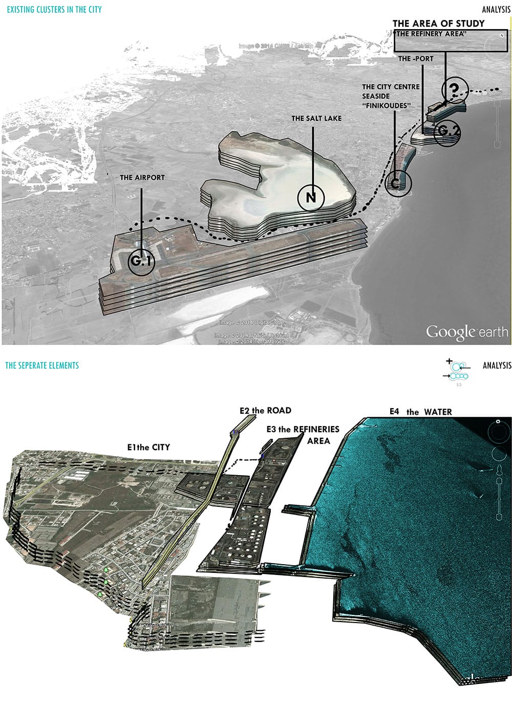
Analysis: The site as “A cluster in the city”/ the separate elements (the road, the “refinery area” and the sea, © Stella Taousiani
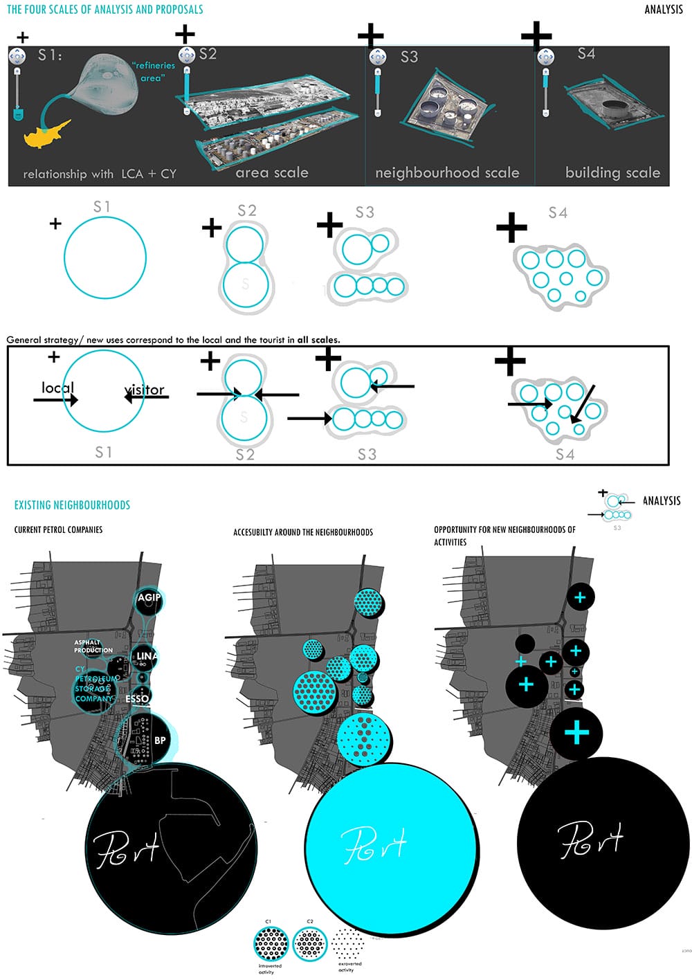
Βασική στρατηγική σε γενικό πλαίσιο, είναι η δημιουργία παρεμβάσεων και χρήσεων σε διαφορετικές κλίμακες (από την κλίμακα του κτηρίου μέχρι την κλίμακα της πόλης) που έχουν ως στόχο την εμπλοκή διαφορετικών ειδών χρηστών και κατ’επέκταση, την ανάμειξη «ντόπιων»- «τουριστών», «πόλης» – «περιοχής μελέτης».
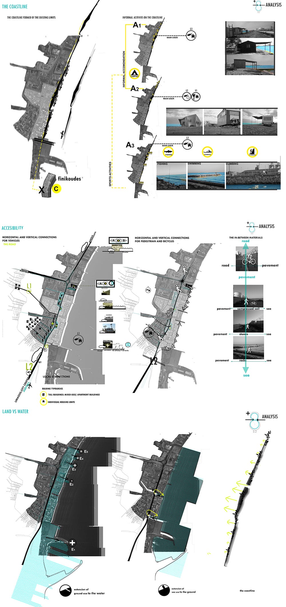
Η ενδιάμεση κλίμακα, «κλίμακα περιοχής» αποτελεί το μεγαλύτερο μέρος μελέτης αλλά και σχεδιαστικών παρεμβάσεων στην εργασία. Συγκεκριμένα σε αυτή την κλίμακα γίνεται αρχικά η αναγνώριση τριών στοιχείων που λειτουργούν ανεξάρτητα μέχρι στιγμής όπως είναι ο δρόμος, η περιοχή με τις υφιστάμενες υποδομές και η θάλασσα.
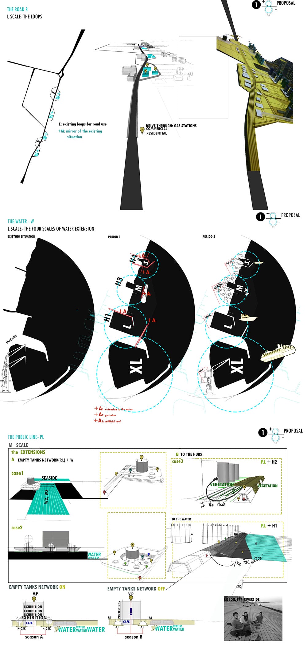
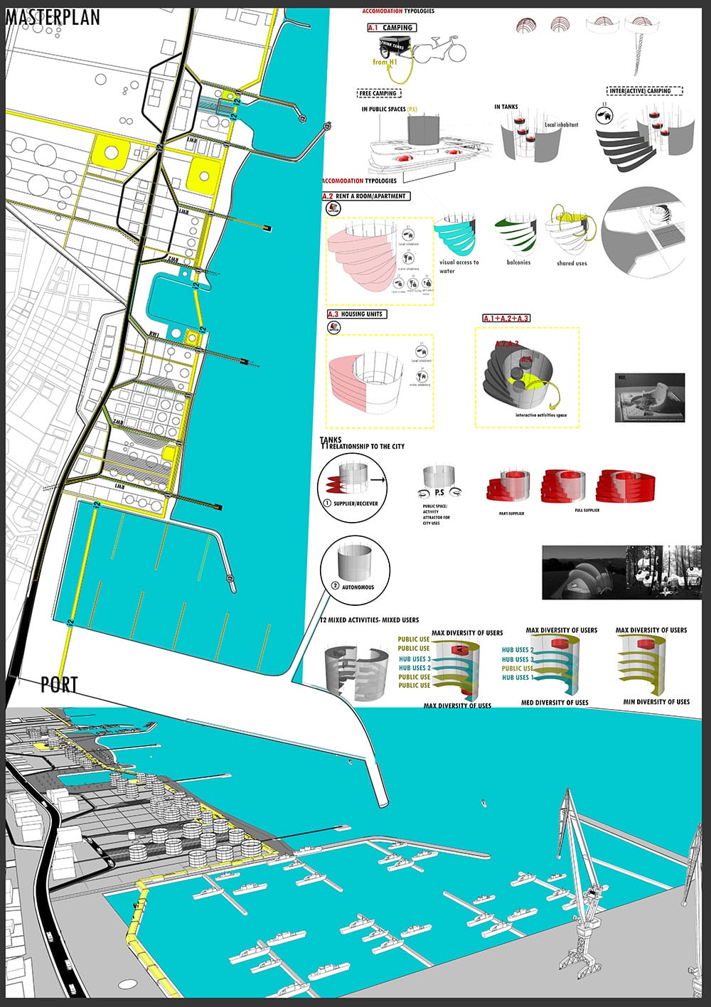
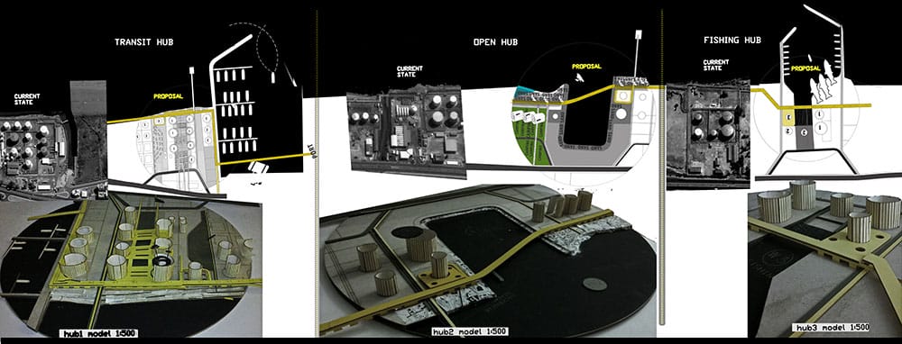
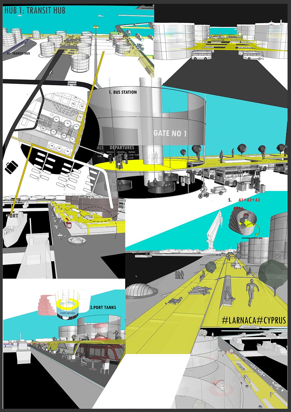
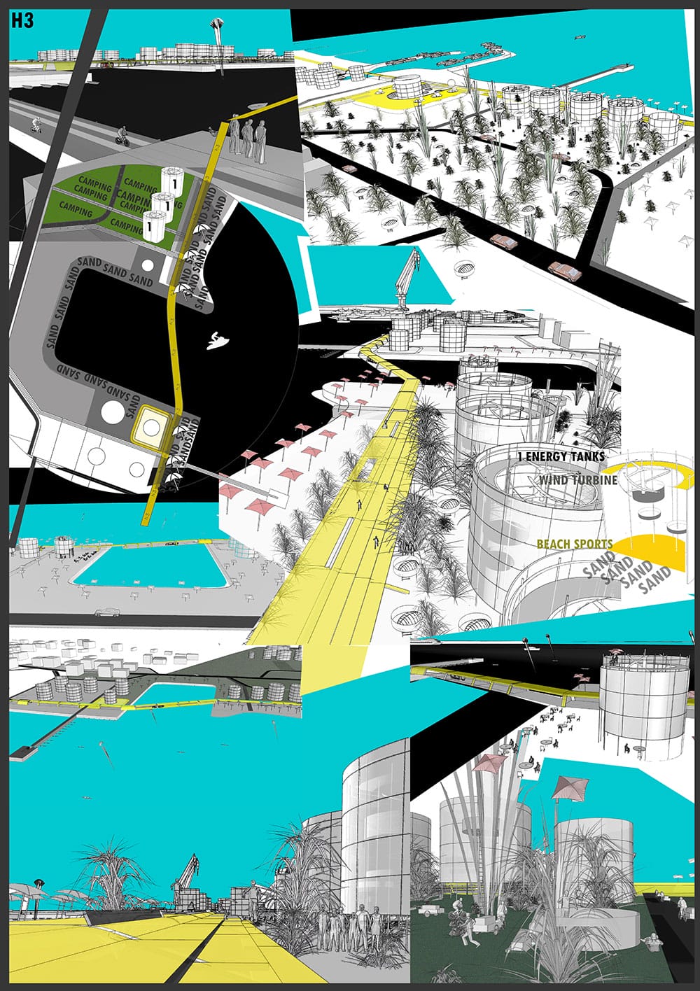
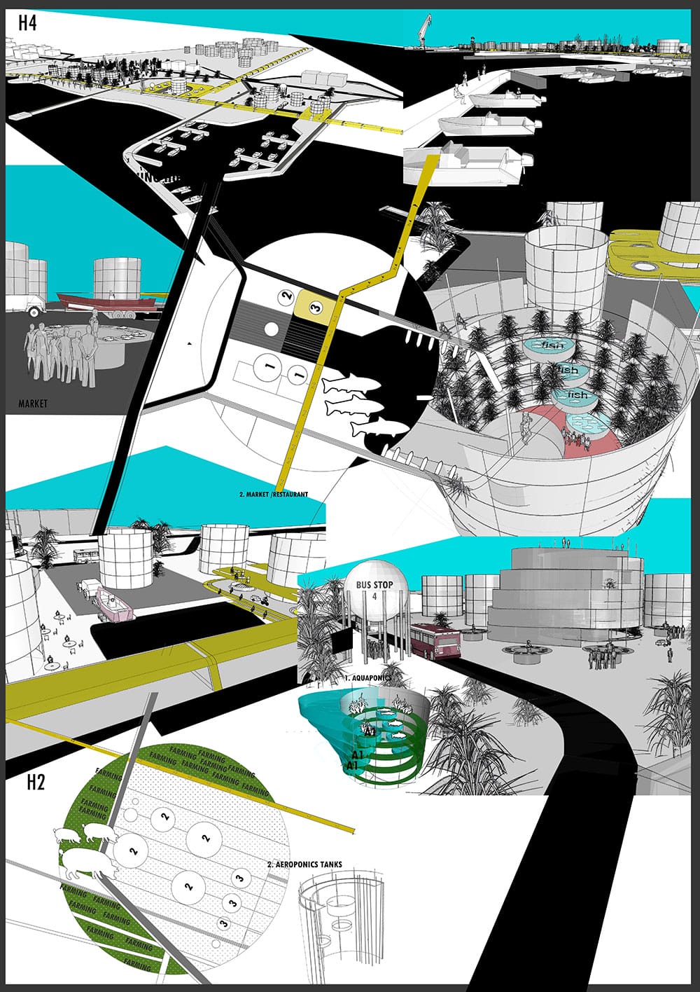
Σε πρώτο στάδιο προτείνεται μέσα από τη διατήρηση των υφιστάμενων υποδομών (και κατ’επέκταση τη διατήρηση ολόκληρης της περιοχής ως τοπόσημο) η δημιουργία νοητών κόμβων(hubs) δραστηριοτήτων. Ο κάθε κόμβος, έχει ρόλο (κυρίως μέσα από χρήση επικράτειας απο την οποία παίρνει και την ονομασία του),να επιτρέπει την εμπλοκή διαφορετικών ομάδων επισκεπτών μέσα από διαφορετικές δραστηριότητες. Οι χρήσεις επικράτειας που προτείνονται στους κόμβους ενισχύουν υφιστάμενες δραστηριότητες που ήδη αναπτύσσονται στην περιοχή ή προσφέρουν στην πόλη χρήσεις που ελλείπονται και συσχετίζονται με υφιστάμενα δίκτυα σε μεγαλύτερες κλίμακες . Μέσα από την ανάλυση υφιστάμενων χρήσεων-χρηστών γίνεται επομένως η διαμόρφωση τεσσάρων κόμβωνs:διαμετακομιστικός, καλλιέργειας και κτηνοτροφίας, δημόσιος πράσινος-ενέργειας και ψαρέματος ( transit, farming agriculture, energy/green και fishing hub.)
Ακολούθως, επιδιώκεται η σχέση διάβρωσης ανάμεσα στα hubs αλλά και στα τρία ασύνδετα στοιχεία της περιοχής. Το πρώτο επιτυγχάνεται μέσα από τη δημιουργία δικτύων χρήσεων (όπως για παράδειγμα το δίκτυο διαμονής) ή προσβάσεων (public line) τα οποία διαχέουν τις λειτουργίες: ανάμεσα στους κόμβους (στην κλίμακα περιοχής) και ανάμεσα στην περιοχή και την πόλη (σε μεγαλύτερη κλίμακα). Το δεύτερο επιτυγχάνεται μέσα από τη διαχείριση των ταχυτήτων του δρόμου με τη δημιουργία εκτροπών (Loops) εκατέρωθεν του, τη δημιουργία κάθετων συνδέσεων (RW lines) από το δρόμο μέχρι θάλασσα και την είσοδο του νερού σε τρείς κλίμακες.
Τέλος, γίνεται μια ανάλυση βασικών τυπολογιών κτηρίων και μελετείται πώς μέσα από την ανάμειξη χρήσεων (που διαμορφώνονται διαφορετικά σε κάθε hub) δημιουργούνται νέες σχέσεις καθημερινότητας και επιτυγχάνεται τελικά το μοίρασμα του χώρου ανάμεσα σε «ντόπιο» και «τουρίστα».
ΑBSTRACT
This diploma thesis simultaneously examines two basic issues. On the one hand it investigates the possibilities for the revival of an industrial wasteland (ex-refinery area in Larnaca, Cyprus); on the other hand it focuses in the meaning and the possibilities of concept of “tourism”.
The area of study is of significant importance regarding to tourism, resulting to the opportunity for further investigation of the term. Starting from the smaller scale, it becomes clear that the area of study creates a strong spatial relationship with its future neighbor: the port terminal. This relationship has given motivation for discussion around the subject from the locals, resulting to proposals which aim to bring “touristic development” to the area. As we move to larger scales, other ways of connection between the area and the subject of tourism are being emerged. The site, as an important part of the city, has the opportunity of creating strong relationships with the city, thus with the biggest airport of the country and finally, with the whole island which is being self-promoted as an ideal “sea, sun, sand” destination.
What do exactly to the terms “tourist” and “touristic development” mean?
How can this abandoned, non-place, disconnected from the city area to become a livable part of the urban fabric all year round?
Aiming to answer to these questions, this research also redefines the term “tourist”. The tourist and the local are reconceptualized as “visitors” who share and inhabit the same space in different periods of time.
The general strategy of the project, is to make interventions on different scales (from the building scale to the city scale) in order to achieve the mixture of different types of users and break the division between the “local” and the “tourist” the “city and the “wasteland”.
The area scale(M) is considered as the most important(and the largest) part of both, the analysis and the designing interventions of the project. In this scale, recognizes three basic elements of the site which currently act independently. These elements are: the road, the area of the existing infrastructure and the sea.
As the starting point of the designing interventions is the proposal of maintaining the existing infrastructure(hence maintaining the entire region as a landmark) and the creation of four hubs of multiple activities. Each hub, intends to cause an interaction between the visitors, by different activities.
The main uses proposed in the hubs are either related to activities which already take place in the site or offer infrastructures/activities currently missing from the city of Larnaca and create connections to the existing local networks.
After analyzing the current users/uses of the area and the city, the following hubs are proposed: transit hub, farming and agriculture hub, public green/energy hub and fishing hub.
Subsequently, a series of designing proposals in order to achieve erosion between the hubs and the three independent elements are being made.
For the erosion between the four hubs, some networks of uses(accommodation network) or networks of access(public line) are proposed to diffuse the uses: between the hubs(in the area scale) , between the city and the area of intervention(in larger scale). The erosion between the three elements is achieved by managing the speed of the road with “the loops” either side of the road, the creation of vertical connections (road-to-water lines), and the entrance of the water in three scales.
Finally, some basic typologies of buildings are being proposed and examined on how they succeed in the creation of new daily-routine relationships between the users and eventually the achievement of creating a common ground between the tourist and the local.


