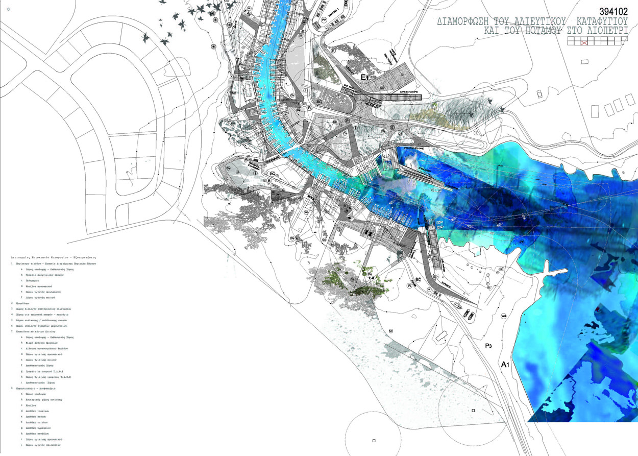
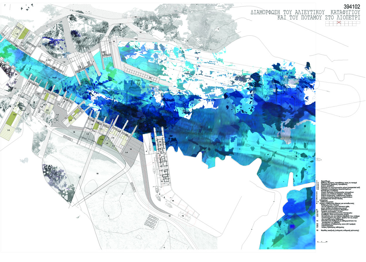
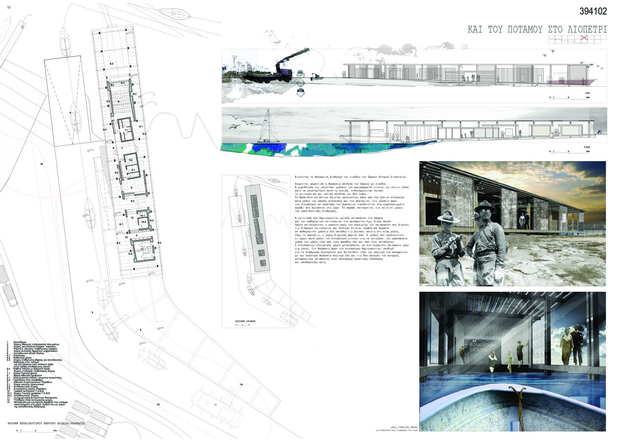
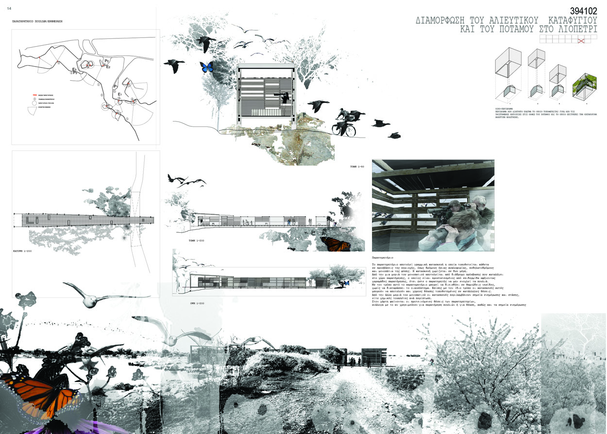
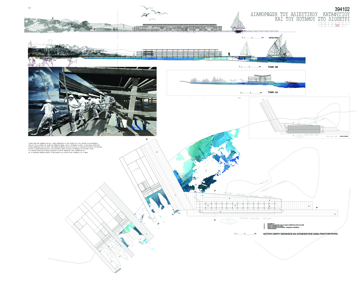
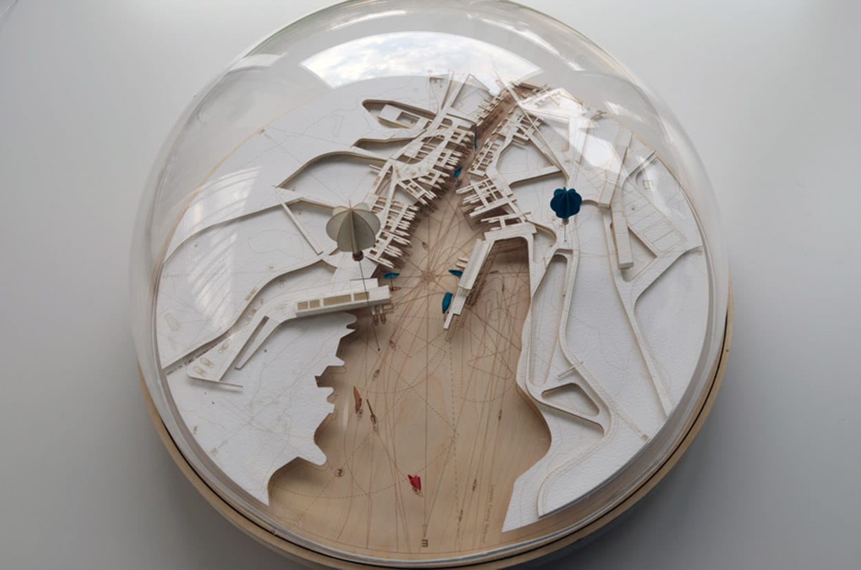
ΔΙΑΜΟΡΦΩΣΗ ΑΛΙΕΥΤΙΚΟΥ ΚΑΤΑΦΥΓΙΟΥ ΚΑΙ ΤΟΥ ΠΟΤΑΜΟΥ ΣΤΟ ΛΙΟΠΕΤΡΙ – Γ΄ ΒΡΑΒΕΙΟ ΣΕ ΑΡΧΙΤΕΚΤΟΝΙΚΟ ΔΙΑΓΩΝΙΣΜΟ
Χριστιάνα Ιωάννου, Χρίστος Παπαστεργίου (Draftworks), Σωκράτης Στρατής (AA&U)
Συνεργάτες: Riccardo Urbano, Αναστασία Αγγελίδου
Υποστήριξη: Έλενα Γενάρη, Μαρία Προκοπίου, Σάββια Παλατέ, Χρυσάνθη Κωνσταντίνου, Κωνσταντίνος Κωνσταντινου, Νέαρχος Κωνσταντίνου, Κατερίνα Νεοφύτου, αρχιτέκτονες
2010 | Πρόταση
Λιοπέτρι, Αμμόχωστος
From Fragment to Eco-Island: An Archipelago à la Carte*
Socrates Stratis
Assistant Professor in Architecture
University of Cyprus
Christiana Ioannou
PhD Candidate in Architecture
Bartlett School of Architecture
Christos Papastergiou
PhD Candidate in Architecture
Bartlett School of Architecture
ABSTRACT
The metaphor of the archipelago, which is the subject matter of this article, has been used in architectural literature as design strategy for shrinking urban environments. Within a contemporary context of increasing co-existence of manmade and natural environments in expanding metropolitan areas, archipelago becomes a pertinent strategy with sustainable potentials. With this article, we aim to introduce possible ways of using this strategy in natural contexts, which are gradually becoming part of expanding urban agglomeration areas. We go on further to talk about an ‘archipelago à la carte’ where the various users can shape their own archipelagos across natural and artificial environments and yet retain amongst them a common ground. The case study is the proposal for the Liopetri Fishing Harbour and Park in Cyprus, which was submitted by our team, (Ioannou, Papastergiou, Stratis) and was awarded the 3d prize in a two stage architectural competition. The article is part of a research by design process, a post-design reflection. We make explicit ideas about achieving sustainability through the reconnection of “asfound” fragmented territories both natural and artificial by the design of an “archipelago à la carte”, yielding to multiple forms of engagement and belonging.
Torsten’s Map or an Engagement à la Carte
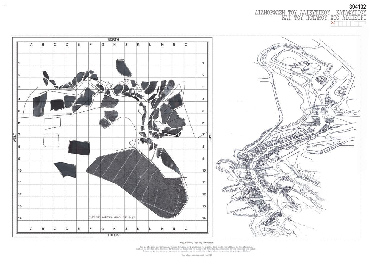
“With the map of the Liopetri Archipelago in his hands Torsten, a retired pilot from Hamburg was looking for the two islands he adopted in the ‘Archipelago’: cultivation island F2 and the fishing-boat platform P87 attached to the island L6. He would share F2 with four other amateur farmers, growing his own vegetables with Paul and Brigit, a couple from Cardiff visiting Cyprus for the summer, Giorgos a local plumber, a fan of organic tomatoes, and Maria the mayor’s wife with a keen interest in growing her own local flavourings to use in her cooking. Torsten’s fishing platform was near the island F2, a ‘Nature Reserve’ island adopted by a secondary school in Nicosia. The schoolchildren were visiting the island every second Friday with their schoolteacher. They took care of the growing bushes and looked carefully for any new eggs of little sea birds. The birds used the old bushes for hiding and the schoolchildren used Torsten’s new platform for storing their horticulture tools. Torsten and the children were getting along well. They had his mobile number and from time to time they would call and ask Torsten to water young plants or make sure that the eggs were still there. Sometimes, he would scold them for being too noisy around his platform when he needed for concentration to unravel his fishing nets. It was at these times that Torsten wished he could have a way to keep the children’s noise apart and rather talk quietly with Petros or Allan, his neighboring fishermen. To isolate himself he would usually leave the platform and continue his work into the peace of his boat floating on the river”¹
Through the article we introduce a process o architectural design that leads from an “as-found’ fragmented condition, to that of an ‘archipelago à la carte’. Along this process fragments are converted into “eco-islands” which obtain discoursive characteristics, meaning a singularity that is however not isolated, but identifies itself through the belonging to a greater whole. The project used as a case study for this article is a submission to a competition for the Liopetri River Park that took place in two stages in 2010 and 2011 respectively about the regeneration of the area of the river and fishing harbour in Liopetri, Cyprus. The project team, consisting of the authors of the article, was short-listed in the first stage and was awarded a third price in the second stage. ²
The “Torsten’s map” which is a story of a potential user of the Liopeti River Park, was used in our proposal as a simulation of a successful “Liopetri archipelago à la carte”. It creates a blueprint of multi-connections between micro-activities assisted by an “eco-islands’ ” infrastructure.
It was back in the 1970s that Alvin Boyarski introduced the concept of “à la carte” (Boyarski, 1970) to bring forward an analysis of the city in terms of layered infrastructures (Shane, 2005 p.148). It was an analysis that was also interested both on highly urbanized nodes and temporary micro-urbanism influencing a lot of important contemporary architectural practice. Architectural Association education was based in fact, on such layered approach to the city and to the movement through its layers and fragments. Recently, the notion of “à la carte” is employed by architects and planners to stress the individual capacity of citizens to choose out of a variety of possibilities, their own way of moving around urban environments, formulating in fact their own everyday life away from previous homogeneous society’s way of moving and living. Such a “à la carte” practice has been actually, augmented because of the maximization of leisure time and dissociation between working and fixed place.
The increase of interaction between man and nature in the Liopetri River is due in fact, to such increase of leisure time. Most of the actual users frequent Liopetri River area for their second job mixed with leisure, (boat fishing, cultivating). However, such activities take place in a vastly fragmented manner based on private priorities with negative consequences on the overall quality of the Liopetri River environment.
Fragmented Territories: “As-Found” Condition
“This is why I came here from England’ said M. showing us around with a wide gesture the self-made jetties. ‘This is the beauty of the place; otherwise I could go to any other marina’. M. was a rather wealthy retired British-born Cypriot who the day before had paid a large crane to pull his 20m boat out of the water for repair; and it was neither easy nor cheap to bring a crane down there. The expensive boat had crushed ashore due to the storm a couple of days before. M. seemed not to be worried about that, neither about the lack of a proper boat-yard with machinery for the repair or of a decent breakwater to prevent the sea from pushing his boat ashore during the storm. He could actually have all these at another marina like that of Limassol. ‘This is the beauty of the place though’ we thought… Ten minutes later K., another fisherman was recounting to us how the place used to be in the past. K. was a local, he had spent all his life around the river and he knew it quite well: ‘The river once was like Vietnam…’ We laughed. ‘Yes!’ he exclaimed ‘Like the rivers in Vietnam that you see in the movies! It was full of bamboo and there was only a narrow route left clear for the boats. There were not so many boats before and the water was fresh. Now, all the fresh water is used in cultivation and the seawater has filled up the river’…”³
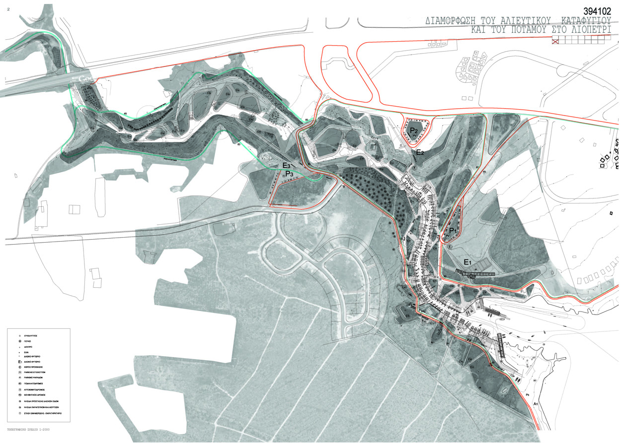
The harbour consists of self-made fishing piers that informally occupy the riverbank, which produce a unique result that many visitors describe as ‘picturesque’ while we would rather describe as an original practice of self-made and self-managed architecture without though having a built-in dimension of a responsibility vis-à-vis the larger scale of Liopetri River Park. The competition brief during the first stage, also asked for ideas about the area of cultivation land along the inland shore of the river, the relocation of some existing buildings such as restaurants and family houses, the incorporation of a large part of a forestry land on the west side of the river –which was eventually removed from the competition brief during the second phase– and the development of a government-owned land on the east side. On the second stage, the brief asked specifically for design proposals concerning ways for the relocation of the amateur fishermen along the river with health and safety regulations taken account of and fishing infrastructure and public access provided. The brief also asked for ideas about how organic cultivations can be placed in the area and how the area can work as a public park, by installing a visitorpark programme, such as a visitor centre, a cafe and a restaurant, and spaces for canoe and kayak learning and hiring.
The fragmentation starts in fact, from the way the area is governed through a division of responsibilities and territories attributed to various State Departments and Authorities without sufficient communication between them. Consequently, such condition was present during the preparation of the competition by excluding on one hand important actors such as the Forestry Department plus, warnings from the Department of Environment were not taken seriously into account. On the other hand, the Community Council and landowners gained uncommon power on decisions perpetrating fragmented logics. This fragmentation of space has occurred indeed, both on political level, as a matter of conflicting jurisdictions between authorities and project actors, and on an actual territorial level, as an overlay of various uses and environments, which many times oppose to each other.
However, we were intrigued by the wisdom of the existing hand-made fishermen’s jetties as well as the qualities of the found elements on the site. Our proposal is based in fact, on a documentation of the existing jetties. Such documentation was extended to all sorts of “as found” fragments, such as pieces of state-owned land, forest parts, private-owned plots and small cultivated fields. In this way, the fragmented condition was not necessarily seen as a negative feature, but in terms of ‘as-found’ condition (Smithsons, 1974, in Aureli, 2011: 209), which could inform the design strategy. For that reason we imagined this fragmented site as being converted into an archipelago of microenvironments that could even extend beyond the limits of the river, to the wider area and become a network of reference for all sorts of users. Our proposal was evolved around the design as a conversion of fragments into self-sustained, self-managed and self-constructed assembly of “ecoislands”. In such archipelago of small naturally, socially and economically sustainable eco-systems, experiencing nature would not mean just visiting it, but dedicating time and effort in cultivating, preserving and sailing it. That is what we will call a “Torsten practice”, aiming to surpass the actual limitations of the fragmented territory. In our proposal the ‘sea’ consists of a ‘soup’ of ‘green corridors’, untreated nature, soft-networks and public service programs that make possible variant connections between the islands.
THE CONCEPT OF ARCHIPELAGO IN ARCHITECTURE AND URBAN DESIGN
Defining the Word “Archipelago”
The Latin word Archipelago, derives from the Greek word αρχιπέλαγος, which can be translated as the ‘principal sea’.3 In Medieval Greek the word was used as the proper name of the Aegean Sea. The main characteristic of the Aegean Sea, which is the large number of islands that it contains, as well as its finite character as an enclosed sea, has linked the word ‘archipelago’ with the image of a network of islands that is connected by sea (Figure 8). In the case of the Aegean archipelago this network has created in antiquity a commonwealth of free states-islands connected by navigation.
Massimo Cacciari (Cacciari, 1997), who also discusses the metaphor of the ‘archipelago’, introduces the link between the Greek word πόντος (pontos) for sea with the Italian word ponte, which means bridge. With this link he argues that for the Greeks, and generally for the peoples around the Mediterranean, the sea was not just a desert, but instead a bridge that connected fragments of land, the islands. The Greek participation in the 10th Venice Biennale of Architecture was about ‘The Dispersed Urbanity of the Aegean Archipelago’. The proposal described the Aegean Archipelago as an entity with distinct features stressing the in-between character of the sea as the key factor of sustainability.
Therefore, the archipelago metaphor accepts the fragmented condition of the world and at the same time allows new kinds of relations between its fragments. It accepts the role of the fragment as an enclosed environment that contains all the necessary to support life, but at the same time cancels out any tendencies of its complete isolation. It is this double character of the archipelago that encourages the development of active boundaries instead of dead limits (Sennett, 2006), along such fragments. We call this kind of activated fragment an eco-island’, as already defined.
Archipelago and the Contemporary City
Since the 1960’s there has been a use of the archipelago in urban design and architecture, however in the beginning not a conscious one. Alison & Peter Smithson in many of their projects from 1960s to 1980s introduce the idea of the urban environment as a network of interconnected ‘clusters’, that is, self-sustained spaces of intensity in the city, with the rest of the city performing the role of ‘corridors’ between these clusters (Smithsons, 1963). In one of their projects they refer to the metaphor of the ‘island’, however they don’t extend to the metaphor of the archipelago. In his ‘Recombinant Urbanism’ David Grahame Shane (2005) talks about urban ‘enclaves’, which then develop connections through ‘armatures’, as he calls the transportation network of a city. For Shane, urban actors are in a perpetual process of developing or canceling out connections –that is, performing connections- between such enclaves.
However, it was Mathias Ungers through his project ‘Berlin: Green Archipelago’ who in the 1970s explicitly introduced this metaphor in urban design, (Aureli 2011, Shane 2005). It was a period when on one hand the fragmentation of the urban environment was being produced and on the other hand the modernist-planning ideal was not anymore valid. Ungers proposed an urban archipelago for the city of Berlin, consisting of a network of built up areas of high urban intensity that like urban-islands float within a ‘sea’ of homogenous urban material. Pier-Vittorio Aureli (Aureli, 2011) discusses Ungers’ project as a valid alternative against the continuous urbanization of contemporary cities. We are particularly interested to Ungers’ example as there are three main issues that link it to our investigation.
Firstly, it is the way a crisis, such as that of a shrinking Berlin, transformed into a driving force for re-envisioning the urban environment. For Ungers, the condition of shrinking is not a negative, but an alternative one. He even stresses this condition by proposing with his project for the city to shrink to its most significant and irreducible parts (Aureli, 2011: 179), providing in this way a model for ‘cities within a city’ (Aureli, 2011: 180). We are situated at such a kind of crisis moment, where we need to confront how the continuous urbanization is relevant to any sustainable priorities, and how areas of natural importance could coexist with extensive built areas.
Secondly, it is the organization of the ‘archipelago’, which depends both on the kind of boundaries of ‘islands’ and the substance of the ‘sea’. The island edges are seen more as porous boundaries rather than non-permeable limits (Sennett 2006, Stratis 2012) creating in this way dialectic relationships between ‘islands’ within the ‘sea’ adding to the discoursive value of the islands. The “sea” in the case of the ‘Berlin Green Archipelago’ consisted either of informal activities relating to agriculture, forests and parks or of all sorts of networks connecting the ‘islands’.
Thirdly, it is the idea of self-organization and self-management that Ungers introduces with his project. His studies on communities that had created their own enclaves with voluntary forms of collaborative structures provided him with ideas about the scale of the islands and their independence from urban centers.
Archipelago as Reconciliation Between Artificial and Natural Environments
Unger’s approach of ‘Green Archipelago’ to shrinking cities could in fact continue to be a valid design concept for the contemporary urban environment where it has become evident that it is more and more difficult to distinguish the artificial environments from the natural ones. Sieverts, contrary to Aureli, in his book ‘Cities without Cities’, introduces the idea of “Zwichenstadt” (Sieverts, 2000), which represents the continuous urbanization with the presence of nature within metropolitan areas. Large open areas of forests, cultivations and natural reserves become part of extensive urban metropolitan areas. Sieverts proposes that such open areas could operate as glue between the diverse urban fragments. There is therefore, the need for inventing extensive synergies between manmade environment and the wilderness, which is in need to be preserved. It is in those synergies that one can find links between the concept of archipelago with both that of Ecological Urbanism (Mostafavi and Doherty, 2010) and of Third Landscape of Gilles Clement (Clement, 1997), in which we believe our posture is inscribed.
A POST DESIGN REFLECTION ON THE “LIOPETRI ARCHIPELAGO”
Expanding the Design Knowledge About “Archipelago à la Carte” Using our design proposal as a vehicle to investigate issues of recombinant practices, (Shane, 2005), within a projected ‘archipelago’ condition, we could contribute in fact, into the creation of engaging sustainable environments, which we call eco-islands, and the formulation of a sustainable design posture, which we call ‘from fragment to ecoisland’. The recombinant process in this project is mainly investigated in the actual territory, and specifically in how, existing fragments of landscapes of any sort, could be converted into eco-islands operating in a larger ‘archipelago’. Through the design proposal we have already applied the notions of ‘archipelago’ and ‘islands’, however through this article, in a post design reflection, we attempt to make explicit plus, expand the knowledge body about these concepts. We have related our problematic to a larger body of architectural knowledge and here we proceed to a post design analysis of the case study. In fact, during the preparation of this article a gradual revealing of tacit knowledge (Alexander, 1977) took place amongst the authors, which constituted a shift from the reflective practice posture of the design proposal to a reflective research one (Schon 1983: 319, 323). The case study is turned indeed, into an explicit knowledge creating device.
Looking back into the Liopetri case study, after having situated on the archipelago literature as well as that of “à la carte” we can locate two main design strategies. The first one is the activation of a found fragment by converting it into an eco-island, and the second one is the establishment of an archipelago by activating a network of all sorts of networks between the eco-islands, achieving a sort of “Liopetri River à la carte” paraphrasing Boyarski’s concept on Chicago. The ‘fragment to eco-island’ strategy converts a fragment to an enclave, able to self-preserve locally a manmade or natural micro-environment and at the same time to gain a translocal role vis-à-vis the rest of the archipelago. This strategy relies mostly to qualities found on site. The ‘archipelago activation’ strategy on the other hand introduces infrastructures of more or less defined routes (pedestrians, cyclists, small vehicles) and programs (public services) that establish variant connections and groupings between the islands. Although still working with found qualities, this second strategy is more interventionist as it manages mobility, transportation and new public programs.
Design Gestures for ‘Fragment to Eco- Island’
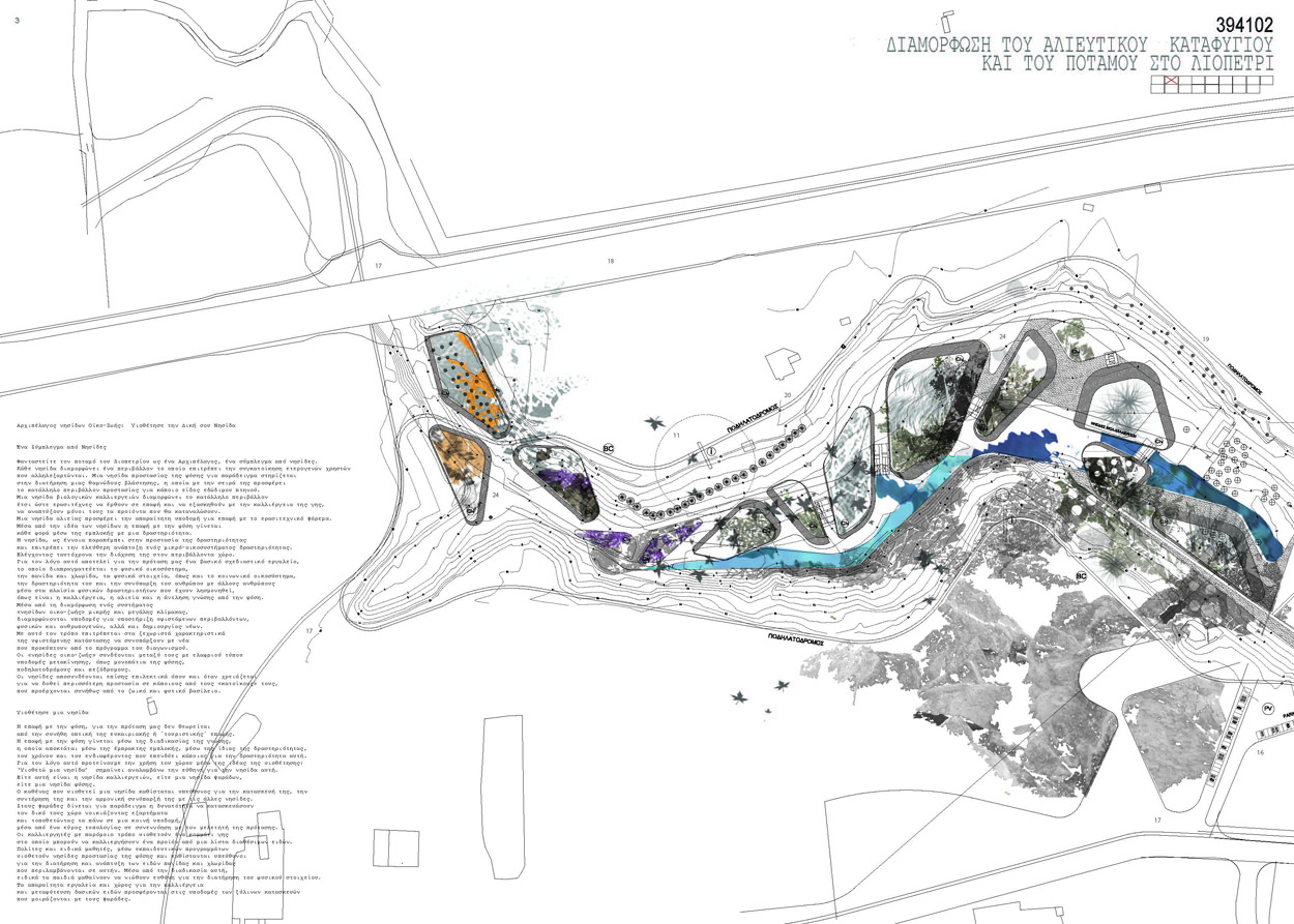
Converting a found fragment into an eco-island in the Liopetri project meant looking for ways of converting it into an identifiable enclave that would have a specific use or create a distinct micro-environment. This function of activation can be sorted in two main design gestures: ‘grafting’ and ‘bounding’, which are both design gestures of identifying. With the gesture of grafting we refer to cases of conversion of fragments into ecoislands by providing them with a specific program. This doesn’t mean that the fragments did not have a specific use, however with the gesture of grafting their use or identity was enhanced and intensified. In this way the converted fragments were sorted into three categories of eco-islands: The ‘Nature Reserve Islands’ (N.I.), the ‘Cultivation Islands’ (C.I.) and the ‘Fishing Islands’ (F.I.), all with a distinct and intensified use.
The second design gesture that of ‘bounding’ should be further sorted into three categories: ‘shaping’, ‘belting’ and ‘structuring’. The case of ‘shaping’ is for example met in the case of the ‘Nature Reserve Islands’ (N.I.). The concern here was for the wilderness to be preserved and left to develop freely and undistracted in a confined space. For that reason defining the boundaries meant providing them with impermeability by a specific form. This is possible by introducing specific routes to surround them. Along the periphery of the eco-islands may be connected to wider entities, such as the adjacent forest. However, when they are adjacent to river park uses, or other islands with more human frequentation, their boundaries get to be more controlled and well defined. The case of ‘belting’ is applied mostly in the case of ‘Cultivation Islands’ (C.I.). This is also a case of boundaries redefinition, which in this case takes place by the introduction of local forestry vegetation, creating a thick island belt with a variant width from two to five meters. It is the thick boundary that attributes a discoursive role to the eco-island by both operating within the larger forest fauna ecosystem, defining the edges of the circulation networks, and at the same time enclosing and protecting an environment for biological cultivation to thrive. In the case of some ‘C.I.’ islands that have parts contiguous to the river, the thick boundary is created as an embankment. The seasonal change in the level of the river creates the effect of a variant width and, consequently, distance from the water. The fact that the embankment is also an “as-found” element opens up the possibility to other elements that could be used as ‘belting’ materials, such as water and soil.
Finally, the third category of the “bounding” gesture, that of ‘structuring’, the island is identified by its own internal organization, which means its distinguishable character as a structure and its materiality. This is the case of the ‘Fishing Islands’ (F.I.) where the fishing platforms are distinguished from the rest of the elements by their materiality, that of wood, as well as by their structure, which provides them with a distinct rectangular shape and a slight elevation from the sandy soil and the water of the river.
Design Gestures for ‘Archipelago Activation’
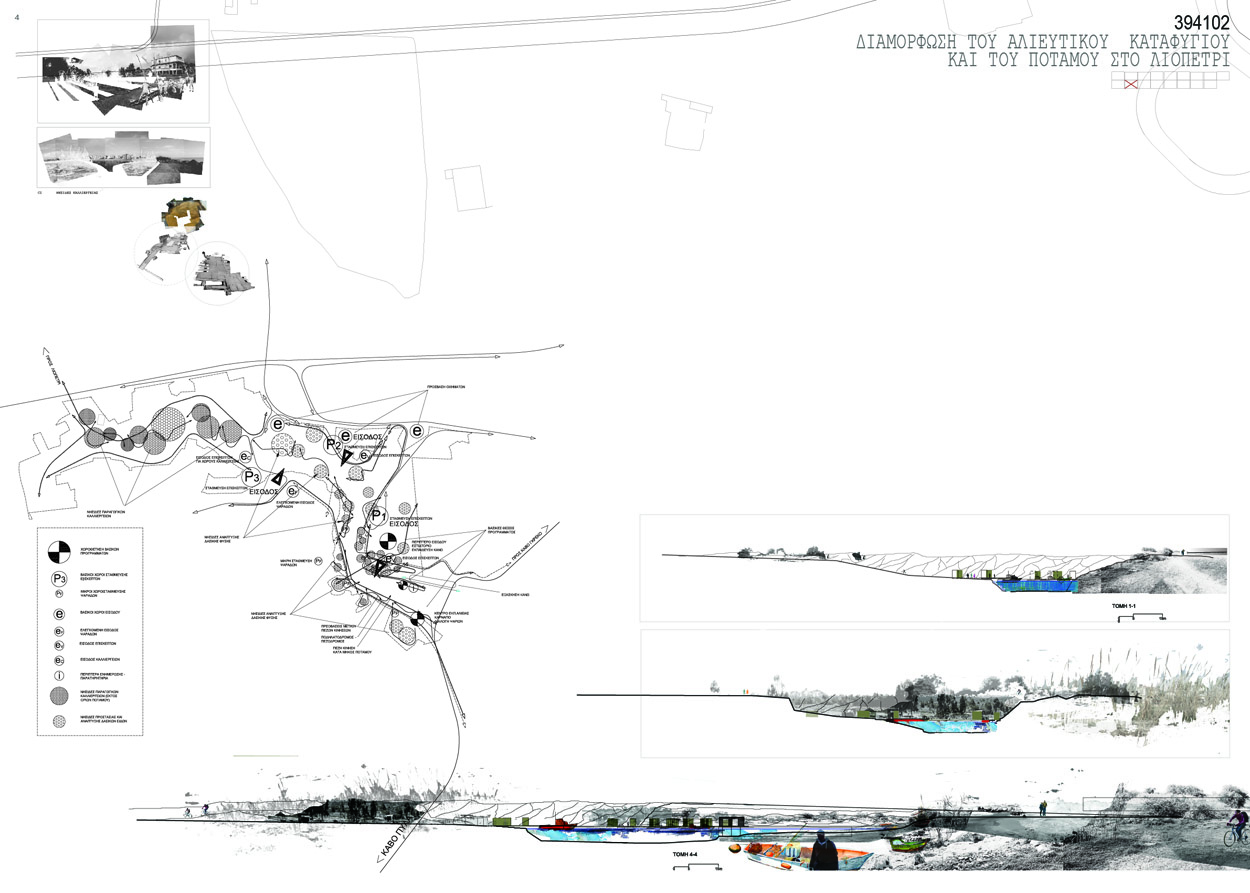
While the ‘fragment to eco-island’ strategy contains design gestures for establishing distinct entities, the ‘archipelago activation’ on the other hand, is a strategy that aims to creating clusters and groupings of these entities. We have sorted this second main strategy into four design gestures: that of ‘creating proximity’, ’sharing common parts’, ‘networking’ and ‘programming’. The task of all four gestures is to activate the ‘sea’ that surrounds the eco-islands, as a ‘soup’ of possibilities for potential groupings amongst eco-islands.
Firstly, ‘Creating proximity’, as a design gesture, is applied in cases where a group of eco-islands may create a set of relationships due to their physical proximity. In this case the space that intermediates between the eco-islands is treated as a surface that can allow both translocal flows that decrease the eco-islands proximity and local flows that increase it. The materiality of the surface is that of an “as- found” element, such as compressed earth. In other cases, where the eco-islands are contiguous to the water, the degree of proximity can be defined by the level of natural flows, like that of the river water.
Secondly, the ‘sharing common parts’ design gesture is applied in cases where two, or more, eco-islands share parts of their body. This happens for example with the parts that some Fishing Islands, (F.I.) share with Nature Reserve Islands, (N.I.). In this case, the structure of the platform itself provides the possibility to adjacent eco-islands to use parts of the platforms. The sharing common parts could be for example, seedbeds for growing forestry species or storage spaces for tools and could create synergy between the two kinds of islands.
Thirdly, the ‘networking’ design gesture deals with all routes that distribute the flow of men and goods within the area. These include pedestrian and bicycle routes, routes for observing nature, as well as vehicle ones and routes of small electrical buses. Such mobility networks may establish synergies between two or more eco-islands regardless their proximity.
Finally, ‘programming’ as a design gesture of creating clusters of ecoislands means managing programs of public use as a means of creating synergies between eco-islands, or connecting them to the networks. Such public programs, as provided by the competition brief is a cafe, a restaurant, bird-watching or information pavilions, an entrance pavilion, an education centre and fishermen facilities. Such programs have been used in at least three different ways of activation: In the first case a public program is placed within a clearing between a cluster of eco-islands acting as a catalyst for new relationships amongst them. In a second case, a public program, which is part of a wider network, may be attached to an eco-island and thus establish a permanent connection to the wider network. In a third case, the public program infiltrates the ecoisland allowing in this way, a controlled porosity.
FROM A ‘GREEN ARCHIPELAGO’ TO AN ‘ARCHIPELAGO À LA CARTE’
Using our proposal as case study for this article, gave us the possiblitity to create further links both between our tacit design knowledge and the project outcome, plus, between the specific design proposal about the “Liopetri Archipelago” with overall problematics of architectural design issues on sustainability.
Design as the Management of Tension Between Human Activities and Ecological Systems
The Liopetri River case is about a natural reserve in which human activities are endangering existing ecological conditions. Cultivating, fishing, boat parking, building, visiting are some of such activities. In other words, the wider design question is not only about the activation of the archipelago on a territorial level, but also about the management of the tension that is produced due to the superimposition of human activities on to existing ecological systems. The Liopetri River area is becoming more and more such an open space within a sprawled development at the highly touristic region of the south east part of Cyprus. The maintenance of wild nature to be left intact by urban development is in fact, a major ecological project in itself. The making of such project has artificial characteristics guided by human priorities, turning therefore, any natural environment into humanly controlled one.
Three Directions of Sustainable Design for “Natures Within Cities”
The contribution of this article to the broader design problematic of sustainability falls into three main directions.
The first one is to take seriously the latent assets of fragmented territories of “as-found” conditions, in order to achieve sustainable development. Liopetri River Park was the example to study but it can be true for a lot of other cases all over the world. The design problematic about allowing the fragment to keep a minimum independence and at the same time to gain an active role vis-à-vis a larger whole is indeed, the basis of sustainable development. Grafting and bounding as design gestures assisted such transformation of an introverted fragment to a discoursive eco-island. To put in fact, the importance to issues of porosity at the ecoislands skins encourages possibilities of coexistence of manmade and natural activities. Plus, the design gestures for activating the archipelago with all sorts of networks, multiply the possibilities of translocal roles to such fragments. In this case, the concept of “à la carte” adds an extra value to archipelago possibilities, confronting creatively the increasing individualization of relations between urban users and “natures within cities”. The “Torsten’s map” is that kind of blueprint of possibilities. It is true that the tension between an increasing urban fragmentation due to the driving forces of the contemporary society and the need to keep a minimum common ground will continue to be a design challenge, bringing architectural discipline to its limits. The case of Liopetri River Park is evocative regarding the fragmentation of jurisdictions and the increasing power of private users, especially, for the southern European countries.
The second direction is the expansion of the concept of archipelago as “cities within cities” to that of “natures within cities”, or even “natures within natures”. In fact, the increasing crisis in the contemporary society yields both to increasing fragmented environments and to new proximities between built and natural fragments within metropolitan areas. Shrinking becomes equally creative as expanding. “Grafting” and “bounding” design gestures become protection strategies for natural environments awaiting for their urban use as “natures within cities”.
The third direction is a sort of combination of the first two ones and stresses the need for engagement of the users in “natures within cities”. Belonging increases with the level of engagement, which is the basis of any self-sustained community. Torsten belongs to the Liopetri River Park because he is very much engaged with all sorts of micro-cosmos incubated within and across the eco-islands.
NOTES
1. Excerpt from the competition proposal.
2. Competition Team: Ioannou, Papastergiou (draftworks*), Stratis (AA & U). Assistants: Urbano, Angelidou. Students: Genari, Ch. Constantinou, Constantinou, N. Constantinou, Neophytou, Palate, Prokopiou
3. Excerpt from the competition proposal.
4. http://en.wikipedia.org/wiki/Archipelago
5. Kotzia Katerina , Konstantopoulos Ilias, Papadopoulos Lois, Filoxenidou Korina, editors “The Dispersed Urbanity of the Aegean Archipelago: 10th International Exhibition of Architecture Venice Biennale: Greek Participation”, Futura, Hellenic Ministry of Culture, Greece, 2006
REFERENCES
ALEXANDER, C. (1977). A Pattern Language: Towns, Buildings, Construction. Oxford University Press, USA
AURELI, P. (2011), The possibility of an absolute architecture, Cambridge, Mass.: MIT Press
BOYARSKI, A. (1970), Chicago à la Carte, in Architectural Associations: The idea of the City, Robin Middleton, ed. (London: Architectural Association 1996)’; article first printed in Architectural Design, No 11, December 1970, 595-640
CACCIARI, M. (1997), L’Arcipelago, Milano, Adelphi Edizioni S.P.A.
CEPL, J. (2006). Oswald Mathias Ungers’s Urban Archipelago for Shrinking Berlin. In: OSWALT PH. Shrinking Cities, Volume 2: Interventions. Ostfildern: Hatje Cantz. pp 187-195.
FINDELI, A. (2008) Searching for Design Research Questions. Q & H Conference, Keynote.
FINDELI, A., COSTE, A. (2007) De la recherche-création à la recherche-projet: un cadre théorique méthodologique pour la recherché architecturale. Lieux Communs (10), pp 139-163.
MOSTAFAVI, M., DOHERTY, G. (eds) (2010), Ecological Urbanism Baden Switzerland: Lars Muller Publishers
SCHON, D., (1983) The Reflective Practitioner; How Professionals Think in Action. Great Britain: Ashgate, Basic Books.
SEGGERN, V.H., WERNER, J., GROSSE-BACHLE, L. (eds), (2008)
Creating Knowledge: Innovation Strategies for Designing Urban Landscapes. Berlin: Jovis.
SENNETT, R. (2006),Viewpoints: architecture and the city in Cities: Architecture and Society, 10th Venice Biennale of Architecture, Italy: Marsilio, pp86-87.
SHANE, G. (2005) Recombinant Urbanism: Conceptual Modeling in Architecture, Urban Design and City Theory, London: John Wiley & Sons Ltd.
SMITHSON P., SMITHSON A. (1974) Without Rhetoric: An Architectural Aesthetic, Cambridge, Mass.: MIT Press.
SMITHSON, P., SMITHSON, A. (2001) The Charged Void, London, The Monacelli Press.
SIEVERTS, T. (2000), Cities without cities – An interpretation of Zwischenstadt, in original language-german, Switzerland: Birkhauser.
STRATIS, S. (2012) Welcome Back In My Back Yard; an urban porosity interrogation, in REBOIS D. (ed.) (2012) Ideas Changing Europan implementations, Paris: Europan Publications, pp 46-50.
STRATIS, S. (2005): Forms of ‘Local / Global’ Dynamics in a Projectbased Action on an Urban-architectural Scale: the Europan Context. Doctorate of Urbanism Thesis. Paris: University of Paris 8
UNGERS, O. M. et al: (1978) Cities within the City: Proposal for the Sommer Akademie for Berlin, Lotus 19, pp. 82-97.
* “From Fragment to Eco-Island: An Archipelago à la Carte” was firstly published in Edinburg Architecture Research, Volume 33, 2013, pp. 71-90


